The Megalithic Phenomenon and the Architecture of Anxiety

The African Frontier: Climate Shock and the Megaliths of the Maghreb

By Nick Nutter | Published: 2026-10-23 | Updated: 2026-10-23

Visited 5 times

Five thousand years ago, the Holocene aridification transformed the Sahara from a verdant savannah into a desert, forcing African pastoralists into a narrow coastal corridor. In the Maghreb (Morocco, Algeria, and Tunisia), this climate shock destroyed early agricultural mega-sites like Oued Beht, which once traded heavily with Iberian elites. Trapped in a shrinking ecological bottleneck, inland herders built thousands of brutalist stone dolmens at sites like Roknia to anchor territorial grazing claims. Conversely, coastal farmers at Kach Kouch maintained vital maritime links across the Strait of Gibraltar, eventually fusing their resilient traditions with arriving Phoenician technologies.

The Sahara Savannah

Five thousand years ago, the Sahara was a lush green landscape. It hosted flowing rivers, deep lakes, and vast savannahs capable of supporting prodigious animal populations. Today, it is an arid wasteland. The acute shift between these two climatic extremes completely reshaped human history across North Africa.

During the African Humid Period, pastoral communities thrived across this bounteous landscape. Their wealth walked on four legs. Anthropologists refer to this phenomenon as the "Cattle Complex" (a cultural system where livestock dictates social status, economic power, and daily survival). Rock art at sites like Tassili n'Ajjer depict sprawling, healthy herds moving freely across the continent. The Holocene aridification abruptly changed this reality. As the global climate shifted, the monsoon rains failed and the Sahara began to dry around 3000 BCE. The transition from a green savannah to the desert we know today took a mere thousand years, or 40 to 50 generations.

The African Frontier: Climate Shock and the Megaliths of the Maghreb - Oued Beht in Morocco
Oued Beht in Morocco

The Forgotten Hub: Oued Beht and the Iberian Connection

Before the Maghreb (the coastal strip encompassing modern Morocco, Algeria, and Tunisia) became a demographic trap, it was a dynamic agricultural powerhouse. Long before the dolmens of Roknia were built, the coastal strip of North Africa was deeply connected to the European mainland.

The proof lies on a limestone ridge overlooking the Oued Beht river in Morocco. Occupied between 3400 and 2900 BCE, Oued Beht is the earliest and largest agricultural mega-site in Africa outside the Nile corridor (Broodbank et al., 2024). Stretching across ten hectares, this settlement was contemporaneous with the great Copper Age bastions of southern Iberia, such as Los Millares.

The two coastlines were not strangers; they were active trading partners. The inhabitants of Oued Beht farmed the same domesticated package of wheat, barley, sheep, and pigs as their Iberian neighbours. They produced dark-on-light painted pottery that perfectly matches styles found in southern Spain. Genetic analysis from Iberian graves reveals the presence of Saharan pastoralists, proving that people, as well as goods, were crossing the Strait of Gibraltar.

Oued Beht solves a major archaeological puzzle from the Iberian Peninsula. When the elites at Valencina de la Concepción buried their 'Ivory Lady' with African ivory and ostrich eggshells, those exotica were flowing through Maghrebian hubs exactly like Oued Beht.

The Anxiety of the Silo

Even at this early date, we see the first whispers of the "Architecture of Anxiety." Oued Beht is defined by its pits. Archaeologists have uncovered a massive concentration of deep, subterranean silos carved into the site, mirroring the 'silo culture' that stretched from Portugal to western Andalucia.

These were not casual storage bins. As the African Humid Period began to wane and the rains became less reliable, the farmers of Oued Beht engaged in large-scale food hoarding. They used heavy polished stone axes to clear land and huge grinding stones to process their harvest, safeguarding the surplus in the bedrock.

This prosperity could not outlast the climate. As the 3rd millennium BCE progressed, the Saharan aridification accelerated. The great agricultural exchange network between Morocco and Iberia fractured. Farming mega-sites like Oued Beht were eventually abandoned, leaving the Maghreb to the nomadic pastoralists fleeing the expanding desert.

The Northern Bottleneck

The pastoralists faced a new, bleak reality. Sand replaced grass, and the herds began to starve, forcing entire populations to move to survive. They pushed north toward the Mediterranean coast. This was not a conscious migration. The herders and their cattle were simply staying within their ecological niche zone as the zone itself moved north.

The Maghreb offered a temporary refuge. Sheltered by the Atlas Mountains, this region retained enough moisture to support grass. The geography quickly created a demographic trap. The shrinking habitable zone confined thousands of migrating herders into a tight coastal corridor, and competition for grazing land skyrocketed.

Roknia and the Architecture of Paranoia

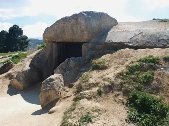
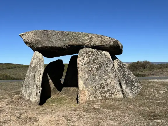
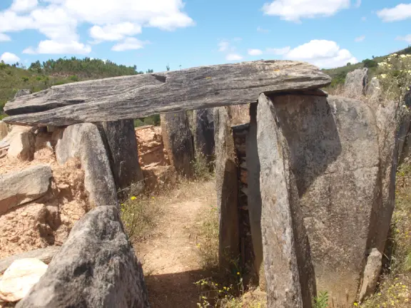
The necropolis of Roknia sits in northeastern Algeria, presenting a bizarre archaeological anomaly. The site contains over 7,000 dolmens spread across a barren rocky plateau barely two square kilometres in area. These structures lack the architectural grandeur of the Iberian or Sardinian megaliths. While built in the classic dolmen style, upright standing stones supporting a heavy capstone above ground, they are drastically scaled down. Averaging barely a metre in length, they are small, brutalist, utilitarian stone boxes. These were not individual graves but collective clan vaults, designed to be reopened generation after generation to receive new bodies.

The builders were not wealthy maritime traders hoarding copper or obsidian. They were cattle herders inhabiting a dying environment. The staggering concentration of tombs at Roknia reveals a landscape saturated with territorial tension. The archaeological record here shows a distinct pattern of behaviour. Whilst thousands of monuments crowd a single plateau, the builders positioned the tombs on prominent ridges overlooking the valleys. The dolmens required minimal engineering, prioritising speed and volume over monumental scale.

Staking Claims in a Shrinking World

The dolmens of Roknia represent the frantic staking of grazing rights. In a world where pastureland meant the difference between life and death, territorial ambiguity was a fatal flaw. The pastoralists used stone to anchor their claims (Savage, 2001).

The first dolmens appeared just as the Saharan aridification reached its climax and stabilised into a hyper-arid desert around 2000 BCE. The populations, now fully confined within the Maghreb bottleneck, began asserting their land rights. Archaeologically, the necropolis was in use for over a millennium, with the bulk of the construction generally dated from the early 2nd millennium BCE through to the 1st millennium BCE (roughly 2000 - 1500 BCE down into the Iron Age and Numidian periods). The necropolis is the result of centuries of continuous, generational land-staking by competing pastoral clans trapped in a shrunken world.

Burying the dead in visible, permanent monuments transformed a transient pastoral group into a rooted, land-holding entity. A dolmen sent a clear message to rival tribes pushing up from the drying south. Our ancestors rest in this rock, and this valley belongs to us.

Isolation in a Shrinking World

The megalithic builders of Iberia, Sardinia, and Sicily were plugged into an extensive maritime exchange network. The pastoralists of the Maghreb were entirely cut off. The initial grave goods at Roknia reflect this isolation. Excavators opening the earliest dolmens did not find imported Alpine greenstone or international Bell Beaker ceramics. They found the material culture of desert survival. The early tombs yield handmade, unpainted pottery, simple bone tools, and beads crafted from ostrich eggshells.

This creates a historical irony. During the Iberian Copper Age zenith (c. 3000–2500 BCE), nomadic ancestors of these African herders likely harvested ostrich eggs. They fed coastal trade networks bound for Spain. By the time the Maghreb herders began building dolmens around 2000 BCE, great Iberian strongholds like Los Millares were already abandoned. The 4.2-kiloyear BP climate shock had completely rewired Mediterranean trade.

This absolute isolation defines their specific strain of anxiety. The Iberian elites built bastions to defend against prestige-hungry rivals. The pastoralists of Roknia built to survive a dying ecology. Yet, despite being disconnected from the coastal cabotage (short-range maritime trade) that linked the Mediterranean islands, these African herders arrived at the exact same architectural solution. When faced with existential stress, human beings instinctively use heavy stone to anchor themselves to the earth.

Only as centuries passed did this closed loop begin to open. Later burials within the Roknia necropolis reveal a subtle material shift. Archaeologists recover tiny quantities of imported metal, specifically small copper rings, bracelets, and fibulae (clothing clasps). Because the Maghreb lacks the rich copper deposits that fuelled the Iberian economy, these trinkets represent the first tentative tendrils of reestablished outside contact. The herders, after a millennium of isolation, were reconnecting with the broader Mediterranean exchange networks, acquiring easily portable metal items rather than massive prestige goods.

Roknia is not an isolated case. Across the eastern Maghreb, sites like Bou Nouara in Algeria, and Djebel Gorra and Ellès in Tunisia, echo this exact phenomenon. Separated by vast distances, independent pastoral clans arrived at the identical architectural solution. They built vast necropolises of miniature dolmens to claim shrinking grazing territories.

The Tyranny of Distance: Divided Destinies

A profound silence exists between the isolated dolmens of Roknia and the coastal settlements of the west. The Maghreb is vast. Over a thousand kilometres of unforgiving terrain, including the jagged peaks of the Rif and the sprawling Atlas Mountains, separate northeastern Algeria from the Strait of Gibraltar.

During the Bronze Age, merchants lacked the ultimate desert transport: the camel. Moving bulk goods laterally across this landscape was economically unviable. The herders of Roknia fought a local war for survival, moving only at the speed of grazing cattle from one shrinking patch of grass to the next. The coastal farmers faced the sea. For them, the Strait of Gibraltar acted as a frictionless maritime highway. Geography dictated their distinct destinies. The sea linked the coast to the Mediterranean network, while the mountains and the expanding desert locked the interior into a closed, terrestrial loop. It is important to realise that within this closed loop, the herders maintained lateral mobility. While trapped latitudinally between the sand and the sea, they moved longitudinally across thousands of kilometres. Pastoral clans from western Algeria to Tunisia intermarried and traded cattle along this horizontal corridor. This lateral exchange kept their populations genetically viable, even as their ecological world shrank.

The African Frontier: Climate Shock and the Megaliths of the Maghreb - Kach Kouch in Morocco
Kach Kouch in Morocco

The Coastal Exception: Mzoura and Kach Kouch

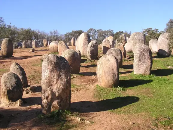
Just 50 kilometres south of Tangier lies the Cromlech of Mzoura. Here, the architecture scales up dramatically. Mzoura is a massive stone circle consisting of 167 monoliths enclosing a central burial mound. The tallest standing stone stands over five metres high. Erecting a monolith of this size requires a hierarchical society possessing the agricultural surplus to feed a massive, organized labour force. Unlike the desperate inland herders, the builders of Mzoura operated within a dynamic maritime zone, projecting power and controlling trade along the Atlantic coast.

While the pastoralists of Roknia were trapped on their rocky inland plateaus, the extreme northwestern coast of the Maghreb tells a different story. The Strait of Gibraltar never completely slammed shut. The recent excavations at Kach Kouch, perched on a limestone outcrop overlooking the Oued Laou Valley in Morocco, prove that the Mediterranean flank of North Africa was not a terra nullius (an empty, unclaimed land) waiting passively for Eastern Mediterranean explorers.

Occupation at Kach Kouch began around 2200 BCE, at the same time as the 4.2-kiloyear BP climate shock was devastating the Iberian mainland and forcing the Saharan herders to build their dolmens. Because Kach Kouch sat at the head of a navigable paleo-estuary, its inhabitants were insulated from total isolation. They maintained a steady, if reduced, maritime lifeline to the Iberian Peninsula.

This coastal connectivity is echoed nearby in the fertile Gharb plain, where archaeologists have found Bell Beaker ceramics, and around Tangier, where Early Bronze Age cist cemeteries (stone-lined graves) mirror those of southern Spain. The Maghreb coast remained part of the shared western Mediterranean cultural vocabulary.

By the time Kach Kouch reached its second phase (1300–900 BCE), it was a stable, prosperous agricultural community living in wattle-and-daub houses. They grew wheat and barley and raised livestock, proving definitively that a settled Bronze Age society thrived here long before the first Phoenician ships appeared on the horizon.

The Eastern Horizon and Local Agency

When those Levantine sailors finally did arrive after 900 BCE, they did not discover a cultural vacuum. They encountered an active, adaptable local population.

The final phase of Kach Kouch (800–600 BCE) captures this hybridisation perfectly. The local inhabitants began importing Eastern Mediterranean technologies. They adopted wheel-thrown pottery like amphorae (large storage jugs) to replace their handmade wares. They acquired iron tools and began planting new cash crops like grapes and olives. They even upgraded their traditional wattle-and-daub architecture by adding Phoenician-style stone plinths (foundations).

This was not a replacement of the local culture, it was a dynamic fusion. The inhabitants of Kach Kouch were not passive recipients of foreign superiority; they were active Mediterranean brokers choosing to upgrade their technology. When the site was peacefully abandoned around 600 BCE, its people likely folded into the booming new coastal cities, such as Carthage, taking their ancient, resilient agricultural heritage with them.

The Maghreb, therefore, offers a dual narrative of prehistoric anxiety and endurance. In the dying interior, the shifting climate forced pastoralists to anchor their claims with thousands of stone dolmens. But on the coast, resilient farming communities leveraged the geography of the Strait of Gibraltar to keep the African frontier connected to the wider world.

References and Further Reading

Broodbank, C., Lucarini, G., Bokbot, Y., et al. (2024). 'Oued Beht, Morocco: a complex early farming society in north-west Africa and its implications for western Mediterranean interaction during later prehistory'. Antiquity, pp. 1-20.

Savage, E. (2001). The Deserted Village: Landscape and History in the Central Sahara. Oxford University Press.

Legacy Reloaded: A dev, an AI, and the relentless pursuit of 100

Enjoying this clean, uncluttered read?

You are currently browsing the result of a massive technical overhaul. My new book, Legacy Reloaded: A dev, an AI, and the relentless pursuit of 100, chronicles the journey of transforming an aging legacy website into a modern, lightning-fast platform that hits the perfect 90+, 100, 100, 100, 3/3 Lighthouse metrics. It’s a story of collaboration between developer and AI, and the stubborn pursuit of technical perfection.

Read the Story

You have finished reading chapter 8

More articles in the The Megalithic Phenomenon and the Architecture of Anxiety series: